

METEONAUTICA
Meteorologia Marina
Bollettino dei naviganti nel Mediterraneo
Previsioni meteo marine a breve termine sul mare Mediterraneo con gli eventuali avvisi di burrasca emessi dal servizio meteorologico francese Meteo France per il settore occidentale e dal servizio meteorologico greco HNMS (Hellenic National Meteorological Service) per il settore orientale nell'ambito del servizio GMDSS (Global Maritime Distress and Safety System) della WMO (World Meteorological Orgnization). Disponibile anche il bollettino per il Mediterraneo e le previsioni DWD (Deutscher Wetterdienst), il servizio meteorologico tedesco.
In questa pagina sono disponibili i più recenti messaggi GMDSS diffusi via Navtex e SafetyNet con le informazioni meteo per la WMO Metarea 3 che comprende l'intero Mediterraneo ad est dello Stretto di Gibilterra nonché il Mar Nero. Gli eventuali avvisi di burrasca (Gale Warning) sono evidenziati per primi ed in nereretto. Di seguito si riportano i settori relativi ai mari italiani compresi nel bollettino Meteomar del COMET/CNMCA con le corrispondenti sub-aree dei bollettini GMDSS indicate tra parentesi. Cliccare per visualizzare la cartina delle due aree con tutti i 54 settori.
-
Metarea III W
Mar Ligure (Ligure), Mar di Corsica (Corse), Tirreno Settentrionale (Elbe), Tirreno Centrale Ovest (Maddalena), Tirreno Centrale Est (Circeo), Tirreno Meridionale Ovest (Carbonara), Tirreno Meridionale Est (Lipari), Mar di Sardegna (Sardaigne), Canale di Sardegna (Annaba e Tunis). Totale 18 sotto-aree. -
Metarea III E
Adriatico Settentrionale (North Adriatic), Adriatico Centrale (Central Adriatic), Adriatico Meridionale (South Adriatic), Ionio Settentrionale (Boot e North Ionio), Ionio Meridionale (Booth, South Ionio e Sidra), Stretto di Sicilia (Melita). Totale 36 sotto-aree.
Archivio GMDSS
Qualora occorressero i bollettini GMDSS emessi nei giorni, mesi o anni passati che al momento non sono disponibili per il download diretto da questa pagina, è sempre possibile richiederli gratuitamente dall'archivio storico del Cybernauta con l'avvertenza che in ogni caso non vengono mai archiviate informazioni diverse dai presenti bollettini GMDSS quali i singoli messaggi Navtex trasmessi in passato (es. via radio) dalle stazioni costiere locali.
Bollettini GMDSS/Navtex ed avvisi di burrasca per i 54 settori del Mediterraneo Ovest ed Est in collaborazione con gli amici di Termoidraulica Coico, Termoidraulica Nigrelli, Coico+3 Articoli Termoidraulici, aziende di Roma specializzate nella fornitura, manutenzione ed installazione di impianti di riscaldamento, condizionamento e climatizzazione, gas e termoclima, pannelli solari termici e fotovoltaici, caldaie e climatizzatori.

Per contattare direttamente il Cybernauta: Mailto@cybernauta
Risposte alle domande più frequenti: FAQ@cybernauta
La pagina Facebook curata dal Cybernauta: Facebook@cybernauta
Bollettino GMDSS / Navtex
Previsioni per la Metarea III del 2024/05/12 08:07 UTC

Bollettino del mare (MeteoMare), medie climatiche, dati oceanografici e previsioni meteo marine per il Mediterraneo.
Il bollettino del mare (Meteomar) con le previsioni meteo marine a medio termine per il Mediterraneo emesso alle ore 00, 06, 12 e 18 UTC da COMET/CNMCA, ultima edizione ed archivio storico.
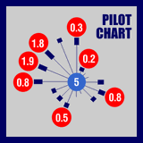
Pilot Chart dei mari italiani e del Mediterraneo, con le medie climatiche mensili, la distribuzione statistica e la rosa dei venti prevalenti.

Grafici e tavole con orario e livello di alta e bassa marea nei prossimi giorni per i principali porti italiani e del Mediterraneo centrale