LOVING TIDES
Since I was a child, the natural phenomenon of the tide greatly
fascinated me. The page of the "Children Encyclopedia" with two
black and white photographs of Mont Saint Michel, "island" and
"peninsula", will always be in my childhood memory.
My interest is widely shared by other Italian yachtsmen who
repeatedly request information on tide forecast programs via E-mail
even if this phenomenon is not particularly relevant for
navigation and safety at sea in the seas surrounding Italy. As a
matter of fact, the range of the tide in this area is of 1'8" from
the mean level; in Genoa, the high tide is of approximately 1'4"
in the spring tide and of 8" in the neap tide.
In the upper Adriatic Sea the situation is slightly different.
Here, the tide may exceed 2'11"; in Venice, particular
meteorological conditions (southeasterly wind and low pressure)
and oscillations of the Adriatic Sea (the so-called "sesse")
determine the phenomenon of the "high waters".
Even if the tide levels in the Italian seas cannot be compared
with the levels existing in Normandy or in Cornwall - in Mont
Saint Michel the tide may reach a maximum of 52'6" - some tide
forecast programs include data regarding several Italian locations.
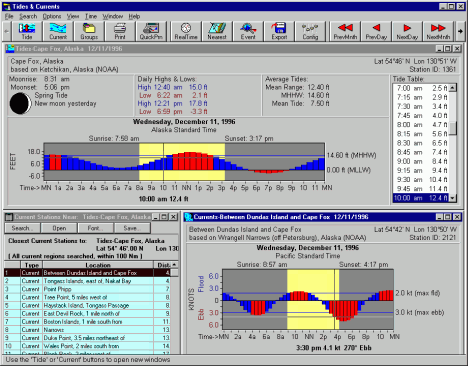
The latest version (2.5) of
Tide & Currents for Windows (T&C)
produced by the Nautical Software of Portland (USA) was recently
published. Official data of thousands of sites all over the world
obtained as a result of an agreement with the British Admiralty
may be used with this new version of the program. There are 13
"Tidal Disks" of 13 corresponding regions: Italy is included in
the disk n. 2 with 34 locations. T&C is probably the most
sophisticated tide forecast software on the market today, covering
the time span 1901-2100. As opposed to the vast majority of
programs of this type that use little initialization constants,
all 223 harmonic components that make up the forecasting model of
the UKHO (United Kingdom Hydrographic Office) are supported for
maximum processing precision. In addition, Chart View, a powerful
electronic chart software produced by the same Oregon-based
company perfectly integrates T&C. The T&C program costs USD 129,
including the NOAA database of either the U.S. East or West Coast
(USD 179 for both databases). The "Tidal Disks" with the Admiralty
data cost USD 75 each. Even if it seems a bit too expensive, one
should keep in mind that the price includes the royalties to be
paid to the British governing department. It is strange that no
offer includes T&C with a Tidal Disk instead of the two American
databases. Whoever is interested in the tides of the Mediterranean
Sea alone, must pay at least USD 204 (USD 129 for the program with
a NOAA database and USD 75 for Tidal Disk n. 2). Another flaw is
the absence of a demo version of the program, that could
eventually be limited in time or to certain locations and that is
generally offered by most software companies. The web page of
Nautical Software includes extended information on the program and
a detailed description of how it works. The reliability of the
forecast, limited to the NOAA database and to the present day or
to the following day, may be tested in a web page available to all
Internet users.
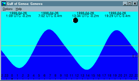
Wxtide 2.2 is the Windows 95 version of the famous Xtide for Unix,
used by some web pages such as Excite Weather or WWW Tide/Current
Predictor. The shareware produced by Mike Hopper includes a
database of over 7,000 locations all over the world - 34 of these
are in Italy and were taken from Tide 2.4, the old MS-DOS program
by Hans Pieper. I contributed to a very small extent to the most
recent version of Wxtide, published at the end of March, by
showing the author some of the main defects we found whenever we
tried to obtain the forecast of several sites in the Med Sea. Even
though the program is extremely easy to use, it may be customized
and configured, both using a menu as well as directly from the
toolbar - the latter is almost always absent in Windows programs.
In addition, it is possible to choose a location by clicking on a
digital map of the world: it is a pity that regional maps are not
available at the moment. The user may choose measuring unit (feet
or meters), time format (12 or 24), time (local or UTC), date of
reference, number of desired days and many other options. The
aspect of the generated graph may be selected by setting colors
and trend (full or empty) and visualization of the lunar phases
and of average level of the tide is possible. One of the most
interesting characteristics of Wxtide is the possibility of
creating, in addition to the wave graph, useful diagrams with
week, month or annual data not only with the timing and the level
of the high and low tides but also with sunrise and sunset time
and moon rise and moon set time. This program is excellent, above
all if one considers that it is completely free of charge.
Swtides 2.26 is an MS-DOS tide forecast program produced by the
Canadian-company Stormy Weather Software. The world database
includes 951 locations, 16 of them are Italian. The demo version
may be unloaded from the Internet and it works very well but for
only 10 times: too little for the expensive registration cost of
USD 95. If compared with other programs, Swtide is less precise as
far as Italian data are concerned. My suggestion is to test and
compare the data processed by the different software programs,
including old programs of official tide tables, in order to choose
the program that gives less average errors for the requested localities.

 Il Cybernauta